Campofrío
Situated near the Sierra de Aracena, to the north of the mining region, in the Andevalo and to the west of the province; in a landscape of hills and small rises in the ground which give forewarning of the mountain range. The hamlet is located among these hills and its Parish church stands out with its characteristic tower.
Places worth visiting are; the Parque de los Cipreses, Dolmen de la Cantina, and the Cabezos Colorados.
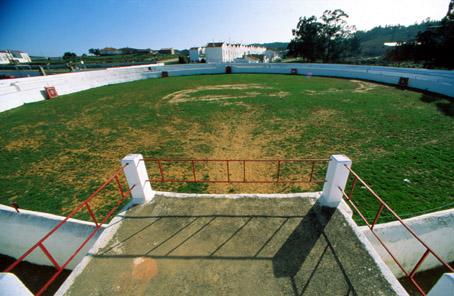
It also has a bullring which is one of the oldest in Spain.
History
The first human settlements date from the Bronze age. Remains from the Iberian age have also been found, such as tombs and a stone stele which has disappeared.
From Roman times there are remains of a Roman road and a necropolis in the Risco del Tesoro.
During the Middle Ages it belonged to the jurisdiction of Aracena until it acheived segregation in 1753 by means of a Royal Privilege granted by Fernando VI.