
Arroyo de las Cañas (Palenciana) – PR-A 8 Trail
The Arroyo de las Cañas Trail – PR-A 8 is in the countryside of Palenciana, located on the border between the two regions of the provinces of Malaga and Cordoba. On one side is Llanos de Antequera, and on the other side is the Subbética region. The Cañas stream is a tributary of the Genil river, in the south of the Subbética region on the so-called western foothills.
The path begins on the asphalted track called the Molinillo Way. After about 300 metres, this path becomes rougher, entering the olive grove and ending after a rustic tool shed.
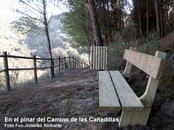
We turn right at the so-called Camino de Las Cañadillas or Cañas, between some almond trees, scrubland and broom, where there is a small descent right at the edge of the slope of the Cañas stream bed, where we have to be very careful. The mouth of this stream in the River Genil is to our left, and in the distance is the town of Benamejí. You can also make out the Sierra de Rute.
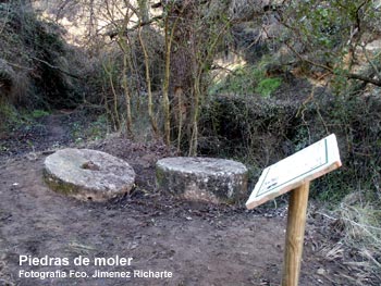
We follow the path, descending, to enter a lush repopulated pine forest, arranged on terraces. After crossing the Molinillo stream over a wooden bridge, flanked by dense vegetation, on our left we can see the grinding stones of an old water mill that was once located near here and whose remains can still be seen, to the right, bordering the gorge.
We continue with the stream on our left and the pine grove on our right and descend to the stream through a beautiful area of brambles, fig trees, poplars, etc. We can also cross the stream over a wooden platform and see an old wash basin, alongside a fountain (with no water), in stunning natural surroundings. Continuing on our way, we ascend alongside the stream and reach a track that leads to the water uptake station on our left.
We turn right to follow this gentle ascent until we leave the pine forest, taking us to an olive grove like at the start of the route; we pass by a house with an irrigation engine and further on we reach the road. We can see El Tejar oil factory, and this point marks the end of the route, but we can continue carefully, next to the road, for another 1.2 km to complete a circular route, back to Palenciana.
Type of Trail: Linear. Trail Status: Approved and Signposted 2004. Total Length: 2.5 Km (one way) Sections: 1 Accessibility: It can be done on foot. Download Brochure
Itineraries

Services and infrastructure
Target audiences
Segments
Season


EXPLORE ANDALUSIA
EXPERIENCES


